


Vikazimut
Vikazimut ၏ ရွင္းလင္းခ်က္
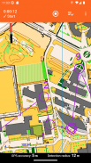
Vikazimut အက်ပလီကေးရှင်းသည် အားကစားလေ့ကျင့်မှုကို လွယ်ကူချောမွေ့စေရန် ရည်ရွယ်သည့် ENSICAEN အင်ဂျင်နီယာကျောင်းမှ ကျောင်းသားပရောဂျက်တစ်ခုဖြစ်သည်။ အပလီကေးရှင်းသည် စာရွက်မြေပုံ၊ သံလိုက်အိမ်မြှောင်နှင့် စစ်ဆေးရေးဂိတ်ကို မှန်ကန်ကြောင်း ဖောက်ပြန်မှုဖြင့် အစားထိုးပြီး ယူထားသော လမ်းကြောင်း၏ နောက်ကြောင်းပြန် ခွဲခြမ်းစိတ်ဖြာမှုကို ပြသသည်။
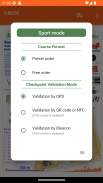
orienteer သည်ပြသထားသည့်မြေပုံမှသူ၏လမ်းကြောင်းကိုရှာဖွေရန်နှင့် QR သို့မဟုတ် NFC ကုဒ်ဖတ်သူများ သို့မဟုတ် iBeacons သို့မဟုတ် GPS အနေအထားမှအလိုအလျောက်စစ်ဆေးရေးဂိတ်များကိုကိုယ်တိုင်စစ်ဆေးရန်အတွက်သူ၏လမ်းကြောင်းကိုအတည်ပြုရန်အပလီကေးရှင်းကိုအသုံးပြုသည်။
လမ်းကြောင်း၏အဆုံးတွင်၊ အပလီကေးရှင်းသည် ပြီးခဲ့သောလမ်းကြောင်းပေါ်ရှိ စာရင်းဇယားများကို ပြသသည်- စုစုပေါင်းအချိန်၊ မီးရှူးတစ်ခုစီကြား ကြားဖြတ်အချိန်နှင့် မြေပုံပေါ်တွင် ပြီးစီးခဲ့သော GPS လမ်းကြောင်းကို ပြသသည်။
Vikazimut တွင် လမ်းလျှောက်မုဒ် နှစ်ခုပါဝင်သည်- အပလီကေးရှင်းသည် မြေပုံပေါ်တွင် ဦးတည်သူ၏ လက်ရှိတည်နေရာကို ပြသသည့် လမ်းလျှောက်မုဒ်နှင့် ၎င်း၏တည်နေရာအတွက် လမ်းညွှန်သူအား အထောက်အကူမပြုသည့် အားကစားမုဒ်တစ်ခုဖြစ်သည်။ လမ်းလျှောက်မုဒ်တွင်၊ အချို့လမ်းကြောင်းများသည် စစ်ဆေးရေးဂိတ်များတွင် ယဉ်ကျေးမှုဆိုင်ရာ အချက်အလက်များကို ပြသသည်။
Vikazimut - ဗားရွင္း 3.15.0
(18-03-2025)Vikazimut - APK သတင္းအခ်က္အလက္
APK ဗားရွင္း: 3.15.0package: fr.ensicaen.vikazimut


က႑တူအက္ပ္မ်ား

သင္ႏွစ္သက္ႏိုင္သည္မ်ားမွာ...


